
AT the top of Carlton Bank, on the road from Carlton to Chop Gate, the high “cliffs” of Cleveland reach out to west and east and offer some of the finest views across to the Tees Valley and the distant Pennines in County Durham.
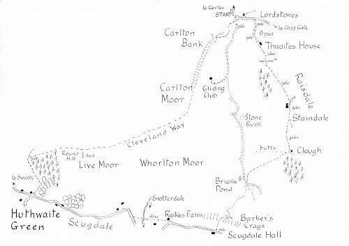
This seven-mile walk follows the Cleveland Way westwards down to Huthwaite Green. From there, it turns up Scugdale before climbing Barker’s Crags and returning along the pretty valley of Raisdale.
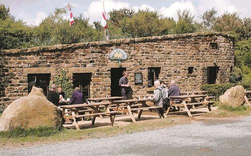
The route starts from the bend in the road at the top of Carlton Bank (GR 523030). Nearby is the Lord Stones cafe which, under new ownership, is closed for refurbishment until autumn 2012. We scale the heights immediately by following the bridleway which acts as the access road to the Carlton Bank Gliding Club. In about 50 paces, Turn right on the Cleveland Way which climbs steeply to the trig point at the top of the bank, at 1,338ft one of the highest points on the moors.
After you have drawn breath and enjoyed the spectacular views, consider the disturbed bank immediately below. In the 17th and 18th centuries this was the site of one of the largest alum works in what is now the national park. The complex industrial processes with their consequent industrial pollution transformed the landscape long before the development of Teesside’s iron industry.
The paved Cleveland Way now makes an easy, gentle descent of almost two miles over Carlton Moor and Live Moor. The panoramic views continue down on to the Cleveland Plain with the outlier of Whorl Hill near Faceby the most prominent feature. Further along, the scarp is covered by the dark green slopes of Arncliff Wood. If the day is clear, the entrance to Wensleydale, some 25 miles distant across the Vale of Mowbray, is visible.
Just before the final, steep descent, look out on the left on the slope of Round Hill for the low ramparts of what is thought to be a small prehistoric hill fort.
At the bottom of a flight of steps, the Cleveland Way turns left and soon joins the trackbed of the railway built in the 1870s to serve the Ailesbury or Whorlton iron mine. The remains of the mine are lost in the trees on the left but spoil heaps disturb the fields on the right. The path then reaches the hamlet of Huthwaite Green in Scugdale where there’s a welcome seat.
Turn left here along the traffic-free lane which serves Scugdale, the name deriving from the Norse for shady valley. It is the only major valley which cuts northwards through the scarp of the Cleveland Hills. Formed by glacial action, it once contained Lake Scugdale which, hemmed in by the ice sheet to the north, eventually broke south through the gap at Scarth Nick.
Apart from the iron mining, the dale was also exploited in the 19th century for its jet deposits. At its maximum in 1877, 39 miners worked in the valley. The impact of these activities on Scugdale is evident high up on the valley sides where a distinct line of excavations is still visible.
In about half a mile, the lane turns sharp right. In another 100 yards go left on a path which drops to cross the beck flowing out of Snotterdale. This might have acquired its name from a farmer who, replying to the inquiry of a surveyor as to the name of the dale, answered: “It’s not a dale”.
The path climbs from the bridge to Raikes Farm to rejoin the road. Continue ahead to the next house, Scugdale Hall.
Turn left here on a bridleway which climbs across two fields and through Barker’s Crags, a line of jagged rocks which dominate the skyline. Beyond the rocks, the bridleway bears to the left for 100 yards or so before turning right over open moorland to join a “yellow” hard core track near the steely waters of tiny Brian’s Pond, hidden in the moorland a few yards ahead on the left.
You could take a short cut of some two miles back to the starting point by following the track past the pond and up across Whorlton Moor. In less than a mile and just beyond the rocky outcrop of Stone Ruck, the bridleway is signed as a track and then a path which passes well to the right of the gliding club hut. It then reaches the club’s access track a third of a mile from our starting point.
The main walk continues across the “yellow” track on a signed path newly cut through the heather. Initially, it heads for a line of wooden shooting butts but in about 200 yards bears right in the direction of the last butt on the the right. It then descends into Raisdale, keeping a large plantation on the right. At the foot are the scanty ruins of Clough farmhouse, where lengths of stone pavement, tumbled walls and an old socketed gate pillar testify to earlier inhabitants.
To the right, there’s a view down tiny Raisdale to its junction with Bilsdale over a mile away. We turn left here along the side of this delightfully remote valley, at this point hemmed in by the slopes of Wath Hill to the right. Though little used, the path is well signed and easy to follow and leads across fields to Staindale, probably the remotest of the valley’s working farms.
Take the access track beyond the farm for a few yards before bearing left on a green path which contours along the valley side to reach Thwaites House in about half a mile. Follow the lane beyond to the Chop Gate road, and turn left.


Comments: Our rules
We want our comments to be a lively and valuable part of our community - a place where readers can debate and engage with the most important local issues. The ability to comment on our stories is a privilege, not a right, however, and that privilege may be withdrawn if it is abused or misused.
Please report any comments that break our rules.
Read the rules hereComments are closed on this article