
JUST north of Durham viaduct lies Ainsley Street, Waddington Street, Mowbray Street, Flass Street and the historic routeway called Redhills Lane.
In a previous Past Times, we have noted that Ainsley was a mustard manufacturer and that Waddington was a Dean. We might also note that Mowbray was in all likelihood Sir JR Mowbray, a 19th century Durham City MP known as the Father of the House of Commons.
Mowbray was a Tory but nearby Flass Street that leads into Redhills Lane, brings us into an area most closely associated with supporters of the Labour party. Redhills is, of course, a rather appropriate name for the site of the Durham miners’ union headquarters, that has been based here since 1915 though of course the name goes back to much earlier times.
Redhills Lane rises steeply along the southern bank of Flass Vale and Flass Street was originally the lower part of the lane.
The blood of battle slain Scotsmen defeated at Neville’s Cross is often cited as an explanation for the name Redhills but in truth it probably has a rather more prosaic explanation being the Reedy hills named from reeds that grew on the banks of the boggy Flass Vale.
Red Hills once belonged to Durham Cathedral Priory and the lane more or less follows the course of the ancient Prior’s Path that headed east to the prior’s retreat at Beau Repaire.
Since 1857, Red Hills Lane has run parallel to the northern bank of the London to Edinburgh railway line that cuts straight through the middle of the hills from which it is named. Redhills railway cutting divides the Durham’s suburbs into two parts with housing in Crossgate Moor and Redhills Lane on one side separated from Hawthorn Terrace, The Avenue and Neville’s Cross to the south.
For the train traveller entering Durham, the cutting blocks off approaching views of the city until the very last minute when the train emerges from Redhills to reveal the breathtaking site of cathedral and castle.
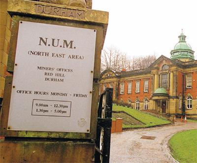
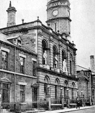
At the bottom of the lane is a lodge house at the entrance to HT Gradon’s red brick miners’ hall that dominates the scene.
Opened in 1915, the hall’s architecture is Edwardian Baroque and the grounds incorporate four statues of mining leaders (Crawford, MacDonald, Forman and Patterson) that were relocated from the earlier miners’ hall in North Road.
Membership of the union increased in the late 19th century and necessitated the construction of the Redhills hall. Its most remarkable feature is an impressive debating chamber that was considered a potential headquarters for an assembly during the regional government referendum a few years ago.
Huge red brick villas belonging to union officials were built alongside the hall and can still be seen but in the mid-19th century there were no houses in Redhills Lane. Nearby Redhills Terrace, just above the hall only dates from the late 19th century.
Opposite the terrace, wedged alongside the railway is St Bede’s mortuary chapel and graveyard of 1866. It is the Roman Catholic cemetery of St Godric’s church in Castle Chare where there was no available space for a graveyard.
Another prominent building in Redhills Lane is the white painted, late 19th century Red Hills Villa.
Predating the nearby union officials’ villas, it was built for Mr Blagdon, proprietor of Blagdon’s Leatherworks.
His works were situated on Framwellgate waterside. The villa, terrace, chapel and miners’ hall can all be seen from the passing train if the inquisitive traveller resists the temptation to view the cathedral in the opposing window.
Despite a one-way system, the upper and middle sections of Redhills Lane are narrow and precarious for both cars and pedestrians. As it climbs, the lane veers away from the railway line in a blind turn and we reach the top of the hill approximately where the forces of Neville and Percy formed the right flank of the English army during the Battle of Neville’s Cross in 1346.
Close by is a hidden 19th century street called Grey Terrace and two large cottage- like buildings near Durham Johnston School.
Once called the Cottage Homes, the buildings were formerly the girls’ and boys’ blocks of a Barnardos home once separated by a fence.
Tucked behind is a small, later building incorporating a small observatory formerly used by the Johnston School.
Redhills Lane eventually terminates at the A167 although across the road to the south is Toll House Road, the main route to Bearpark.
Named from an old tollgate that stood nearby it forms part of the remaining course of the Prior’s Path.
The old path veered off from the present road near Arbour House Farm that stands prominently on a nearby hill before continuing north towards Beau Repaire.
Returning to the top of Redhills Lane, we find the Victorian settlement of Crossgate Moor that faces the A167 or Great North Road. It was named from the surrounding common land enclosed in 1769 but the settlement didn’t come into being until the second half of the 19th century.
It consisted of the terrace overlooking the road and another behind called Neville Terrace of 1877.
A new housing development called Red Hills Mews has recently emerged behind this terrace.
These older terraces lie south of Durham Johnston School but the school has only been here since 1952. It was relocated from an earlier site at South Street in the city centre. Until recent times, the Redhills Hotel stood close to here but this has now gone.
Compared to settlements at Framwellgate Moor and Gilesgate Moor that came into being in the 1830s, Crossgate Moor was a tiny latecomer. It wasn’t a pit village like Framwellgate Moor or a scattering of pit terraces like Gilesgate Moor, although a significant number of 19th century residents were coke workers at neighbouring collieries to the west.
Crossgate Moor only developed as a suburb in the 20th century. Urban growth took place during the 1940s, 50s and 60s when housing developed to the south in and around the street called St Monica Grove, but here we have strayed away from the course of Redhills Lane.


Comments: Our rules
We want our comments to be a lively and valuable part of our community - a place where readers can debate and engage with the most important local issues. The ability to comment on our stories is a privilege, not a right, however, and that privilege may be withdrawn if it is abused or misused.
Please report any comments that break our rules.
Read the rules here