
Publicans, parishioners and pupils were all part of life in an early mining settlement.
This was certainly true of Belmont parish that consisted, from 1856, of Gilesgate Moor, New Durham, Dragon Villa, Carrville and Broomside and a handful of farms like High Grange and Ravensflatt.
With the exception of the farms, these communities were then only a few decades old and its inhabitants were mainly miners. Employment was at seven local collieries, a brickworks and, after 1867, an ironworks.
Chapels, schools and pubs had already sprung into existence before Belmont's Anglican parish church was erected in 1856. The first chapel in 1835 was a Wesleyan chapel in Broomside's Bainbridge Street, but Wesleyans also built chapels at Dragon Lane, opposite Teasdale Terrace, and on Gilesgate Bank in 1869, where the building is now an undertaker's.
The Broomside chapel was demolished and replaced by a new one in Carrville High Street in 1881 called Grange Chapel, probably from its proximity to the Grange Inn.
The New Connexion Methodists established a chapel in Chapel Street, New Durham in Gilesgate Moor in 1838, but this later relocated to a neighbouring drill hall that also served as a school.
A Primitive Methodist Chapel was erected in Ernest Place, Gilesgate Moor, in 1852 and, though no longer a chapel, the building can still be seen.
At Carrville, the Primitive Methodists worshipped on the north side of the High Street from 1839, relocating to the south side in 1868.
When the various strands of Methodism merged in the mid-20th century, it would serve the whole area, until demolished and replaced by a spacious modern chapel in 2002.
The first school in the area was erected in St Mary Magdalene parish churchyard at Broomside in 1838, on land granted by the Pemberton family.
After 1872, it only catered for infants, and a new stone school was built just across Broomside Lane. The churchyard school was superceded by a nearby brick-built infants school in the early 20th century.
Belmont's present junior and comprehensive schools, built in the 1960s, and an infants school of 1980, stand near these older establishments.
The comprehensive was built on the site of Ravensflatt, a farm mentioned in 1364. It had probably belonged to John Raven, mentioned in connection with Raven's Meadows, at West Rainton, in 1365. Ravensflatt land extended west into what is now Dragonville Industrial Estate, an area now dominated by Durham Retail Park.
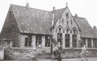
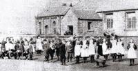
Victorian schools in and around Gilesgate Moor included St Giles' School, (Gate School) of 1874. Demolished in the late 1960s, its site is now occupied by a petrol station near the Durham Light Infantryman pub. Only the school wall remains. Also gone is a late Victorian infants school that stood behind neighbouring Young Street.
A third Victorian school called Old Durham School, or Londonderry School, after its founder, Lady Londonderry, occupied a former military barracks on the corner of Sherburn Road and Dragon Lane from about 1894.
Later called Vane Villas, it was demolished in recent times. It was one of three barracks in the area at one time or another.
In 1905, a corrugated iron council school was built at the opposite end of Dragon Lane at the junction with Sunderland Road where a car saleroom now stands.
Affectionately called the Tin School, it operated until 1972 but was demolished a decade later. It was one of six corrugated schools in Durham.
Others could be found at Ushaw Moor, Brandon, Cassop, Esh Winning and Witton Gilbert. Today, the modern schools of the Gilesgate Moor area are situated near Bradford Crescent, Sherburn Road Estate and Mill Lane.
Schools and chapels were essential elements of a mining community, but for many the pubs were the most important institutions. In the 19th century, the Gilesgate Moor area had an astonishing array of pubs.
New Durham and Dragonville were home to the Rising Sun, Whitwell Inn, The Victoria, The Lass O' Gowrie, Bay Horse, Dragon Villa and The George and Dragon, all on or near the eastern end of Sherburn Road.
At the western end, as today, stood the Queen's Head at "Sherburn Road Ends" and opposite on Gilesgate bank was another pub, The Bay Horse pub which is now the Durham Light Infantryman, or DLI pub.
A little further down the bank, next to the former Methodist chapel now occupied by an undertaker was the Canteen Inn, or For Alls, which was used by soldiers from the local barracks.
Other Victorian pubs included the Bonny Pit Lad, in Ernest Place, and the Grapes, in neighbouring Lodge Hill.
The Lord Seaham (named after the Londonderrys) in Dragonville's Teasdale Terrace was Victorian but is now called the Gilesgate Moor Hotel.
It should not be confused with Gilesgate Moor Inn that stood on Sunderland Road from the 1860s almost opposite the Grange Foundry Inn.
The Grange Foundry Inn, a Victorian establishment is still in existence and was named after an ironworks that stood a mile away at Belmont.
Other Sunderland Road pubs in existence by Victorian times were the Londonderry Arms, The Travellers Rest, The Hare and Hounds, Railway Coach (also known as The Three Horse Shoes) and, in Alma Place, at the eastern end of the road, the Foresters Arms. Alma was incidentally the name of a battle fought in 1854 during the Crimean War.
Before the construction of the motorway, if we had continued east along Sunderland Road from Alma Place, we would reach the junction of Broomside Lane and Carrville High Street at the Sporstman's Inn.
Along Broomside Lane, we would have found Victorian pubs called the Masons Arms (or Stanley Hotel), the Travellers Rest (later relocated) and, beyond the junction with Bainbridge Street, another Londonderry Arms.
In Carrville High Street, at the junction with Bainbridge Street, was the Grange Inn, still there and opposite stood the Wild Boar.
South along the High Street was the Grey Horse, The Two Mile Stone Inn and The Kepier Grange Inn. From here, we could return (assuming that we were still capable of standing) to the Sportsmans Arms and head into Gilesgate Moor to start all over again.


Comments: Our rules
We want our comments to be a lively and valuable part of our community - a place where readers can debate and engage with the most important local issues. The ability to comment on our stories is a privilege, not a right, however, and that privilege may be withdrawn if it is abused or misused.
Please report any comments that break our rules.
Read the rules hereComments are closed on this article