
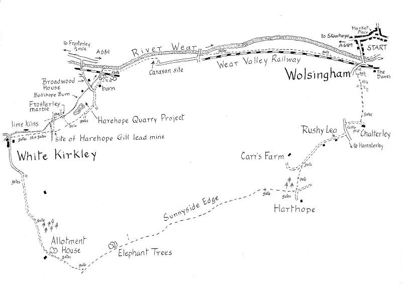
Walk facts – Wolsingham to White Kirkley and back
Distance: Nine miles (six-and-a-half if bus is used)
Time: Five hours
Grade: Moderate, only one short climb
Conditions: Well-signed field paths and moor tracks
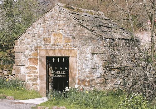
Refreshments: Wolsingham Map: OS Explorer Map OL31.
WOLSINGHAM, with its network of radiating paths, is an excellent centre for exploring middle Weardale. This nine-mile walk heads for the heights on the south side of the valley before descending to explore the leafy glades of Bollihope Burn which, in the 19th century, was a centre of intense industrial activity. The return is made by the easy riverside path.
We start from the market place in the centre of the little town (GR 076373). Follow Front Street westwards (the main A689 to Stanhope). In 100 yards on the left we pass Whitfield House, of about 1700, a large town residence which looks a little out of place in Wolsingham.
More in keeping are Whitfield Cottages, next door, dated 1677, once the Pack Horse Inn.
Next turn left down the road to Hamsterley. This soon crosses the Wear by a 19th century lattice girder bridge, followed by a handsome ‘skew’ bridge over what was the Wear Valley Extension Railway built in the 1840s for transporting the mineral resources of the dale which included whinstone, limestone, ganister and fluorspar. Today, as the Wear Valley Railway, it’s establishing itself as a tourist attraction.
Just beyond the bridge a lane goes left to The Denes and from the corner a track strikes off uphill through trees. Follow it for a few yards to two footpath signs on the left. Take the path which is signed uphill. It’s a short steep climb. You will pass a radio transmitter hut on the right before heading for a large tree trunk on the skyline. From the tree the path crosses a farm track and continues over three fields to Chatterley Farm. Turn right when you reach the farm track and go left when you reach the Hamsterley road.
In 150 yards, turn right on to Rushy Lea Lane near a sturdy sign to Carr’s Farm. It’s now flat, easy walking, a chance to take breath and admire the extensive views up Weardale.
After the first gate in half a mile we leave the farm track and bear left on a green bridleway that runs alongside a wall to a gate. The right of way then goes across the middle of the next field to the far end of a plantation where it joins the lane to Harthope Farm.
We turn right here through a gate and for the next two miles follow a rough track, with a wall on the right marking the boundary between the open moorland and the grazing lands of the valley side. Again it makes for easy walking and affords sweeping views of the dale with Stanhope in the middle distance and the Pennines beyond.
The last mile is dominated by a clump of windswept beeches on the skyline. Known as the Elephant Trees, they are an eye-catcher for much of mid-Weardale and are carved with a mass of initials, many now more than 60 years old.
In another 200 yards, we turn right through a gate off the moorland and follow a hardcore track down past Allotment House. It soon becomes a tarred lane which descends gently through farmland to the hamlet of White Kirkley, one of the early medieval settlements in the dale.
Turn right opposite White Kirkley Farm and head over the next field to the side of the Bollihope Burn, which here flows through a mini-gorge cut in the limestone. On the other side are the impressive ruins of Bishopley Lime Kilns, built in the mid 19th century to provide lime for agricultural use. They closed in 1975.
The path stays in close contact with the burn and in another 400 yards enters Harehope Gill. An information board records the history of the gill’s lead mine. The remains are scanty but the low semi-circular entrance to the mine on the right emphasises the harsh conditions in which the miners worked.
It’s worthwhile making a short diversion here. After crossing the stream, bear immediately left past the ruined mineshop or living quarters to a footbridge over Bollihope Burn. On the far side go right, over a stile, following the burn down to a second bridge.
Below it the stream flows over an outcrop of Frosterley marble. Geologically it’s a 310-million-year-old black limestone containing the white fossils of an extinct coral. When polished it resembles very fine black and white marble – there’s a good example on the river bank by the bridge. The fonts in Frosterley and Stanhope churches, a sculpture on Frosterley station platform, the chapel in the palace at Bishop Auckland and the Chapel of the Nine Altars in Durham Cathedral are all made from it.
On the other side of the bridge, the path climbs back to rejoin the route from White Kirkley. Turn left and follow it high above Harehope Quarry. From the quarry in the early 20th century, millions of tons of limestone were extracted for industrial purposes. Today it is being put to use as a project “to demonstrate practically a more sustainable way of living”. From our path a fishing lake, carp pond and reed beds can be made out. When you reach a tarred lane bear left downhill.
At the bottom there’s a junction. The tarred lane swings to the left. If you wish to cut the walk by over two miles follow the lane past the entrance to the quarry and then Broadwood House. You will the cross the railway and the Wear to reach the bus route on the A689 (not Sundays).
The main walk goes to the right at the junction mentioned above. After passing a large barn on the right the track forks. Bear left on a green path which climbs through trees before dropping to cross the railway before reaching the river bank. Turn right.
The riverside path makes for a delightful amble with the Wear a constant companion either close at hand or a field away. After a quarter of a mile it passes through a caravan site. On the far side follow the access road across immaculate lawns. The road crosses the Wear but we continue ahead across fields for another mile and a half to Wolsingham Bridge.


Comments: Our rules
We want our comments to be a lively and valuable part of our community - a place where readers can debate and engage with the most important local issues. The ability to comment on our stories is a privilege, not a right, however, and that privilege may be withdrawn if it is abused or misused.
Please report any comments that break our rules.
Read the rules hereComments are closed on this article